TeleCense: Satellite data and demographic expertise to help you take the best decisions

  Population growth and displacement in emerging countries is one of the major challenges facing humanity. 
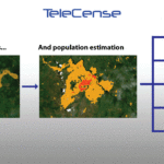
TeleCense accurately assesses the building footprint and population distribution and their evolution. Knowing precisely where populations live is a fundamental element in the decision-making process, and there are many fields of application. Diginove has developed a TeleCense product that combines satellite image processing and demographic expertise to integrate the decision-making process...
Read More

DIGINOVE and geolocated imagery

For more than 15 years, DIGINOVE designs and develops the heart of the image processing software for the ground segments of many french civil and military observation satellites. The performance and the flexibility of its image processing software engine allow our products to process very large images (hundreds of gigabytes, as most of the recent satellites produce) as well as more traditional documents, but also images with complex components (panchromatic, multispectral, hyperspectral or sa...
Read More